Sponsored

OnX, Trails OffRoad or AllTrails

DubaiMarauder

Well-Known Member
First Name
Alex
Joined
Aug 6, 2020
Threads
8
Messages
394
Reaction score
572
Location
Fort Worth, TX.
Vehicle(s)
2023 Wrangler Rubicon Unlimited EcoDiesel FarOut
Occupation
Truck Driver
Vehicle Showcase
1
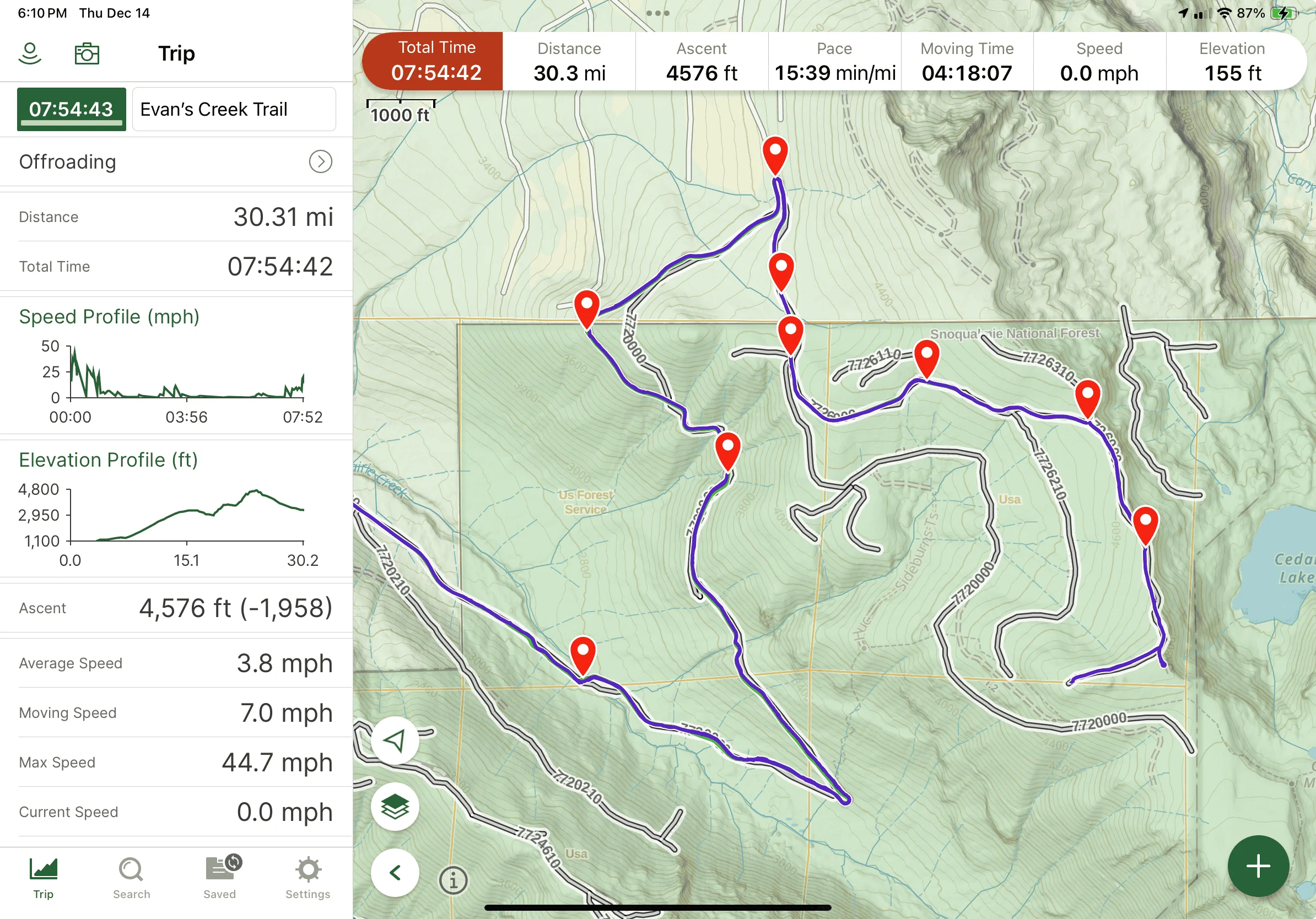
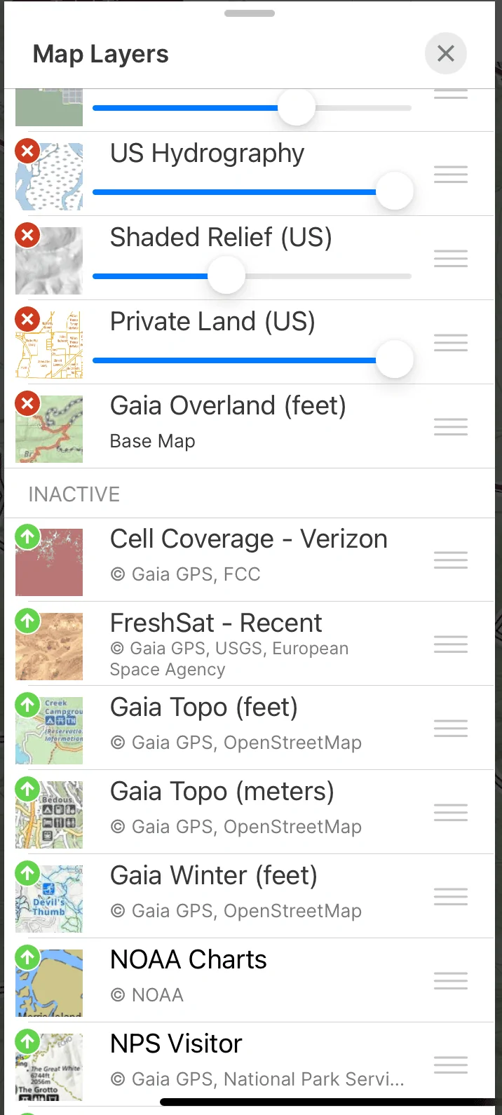
Does anyone have any experience with these apps that can provide a good comparison between the 3? Which do you prefer and why? Pros and cons of each?
Sponsored


Go1712

Well-Known Member
First Name
David
Joined
Nov 12, 2023
Threads
18
Messages
420
Reaction score
465
Location
San Diego
Vehicle(s)
2020 JLU Sport S
Build Thread
Link
Clubs
 
I use Gaia and trails Offroad and I like them both. Plenty to find trails and map them.
 

jhackathorne

Well-Known Member
First Name
Joe
Joined
Dec 7, 2020
Threads
12
Messages
1,455
Reaction score
2,522
Location
Denver
Vehicle(s)
'21 JLUR
Alltrails is going to be the last choice of nearly every single person on this site. It is mainly geared to hiking with a couple other options.

Trails Offroad is my top choice. OnX was too complicated as was Gaia. At least for me. Trails Offroad is simple to use and has tons of trails on it. Granted I am in CO so we have a large selection which makes it easier.
 

Go1712

Well-Known Member
First Name
David
Joined
Nov 12, 2023
Threads
18
Messages
420
Reaction score
465
Location
San Diego
Vehicle(s)
2020 JLU Sport S
Build Thread
Link
Clubs
 
Alltrails is going to be the last choice of nearly every single person on this site. It is mainly geared to hiking with a couple other options.

Trails Offroad is my top choice. OnX was too complicated as was Gaia. At least for me. Trails Offroad is simple to use and has tons of trails on it. Granted I am in CO so we have a large selection which makes it easier.
Trail Offroad is nice bc it also shows you nearby trails and highlights on the trail (paid version)
 

dragoneggs

Well-Known Member
First Name
Mark
Joined
Dec 14, 2021
Threads
73
Messages
9,293
Reaction score
40,593
Location
Seabeck, WA
Vehicle(s)
'22 Snazzberry Pearl JLR
Build Thread
Link
Clubs
 
Simple and informative is TrailsOffroad. Waypoint info and the trail writeups are good.

I use Gaia and upload the TrailsOffroad info into it. Long learning curve but so much information with layers makes it very powerful. So the two together is a great match as you learn.

A few of us wheeled with the couple of the TrailsOffroad guys a few weeks ago. They are responsible for mapping and providing content for Washington State. They routinely update the info to keep the trail status up to date and work with the rangers and others. A nice network.

If you do get TrailsOffroad, I recommend you try to connect with your local guys. If they are like the guys I met, you will be glad you did. Wealth of info and experience and guidance, including recovery, etc.

Gaia is something you should consider if you like maps. Tons of different maps. Again there is a learning curve but if you play with it routinely at home to learn the interface, before you go out on the trail, you will appreciate it more and more.

Again you can use TrailsOffroad as your starter while you learn Gaia.
 

Sponsored

Ratbert

Well-Known Member
First Name
John
Joined
Jun 20, 2020
Threads
159
Messages
16,061
Reaction score
25,041
Location
PNW
Vehicle(s)
2022 AEV JL370 JLURD
Build Thread
Link
Occupation
Software Engineer
Clubs
 
It depends on where you run trails.

For me (in CO) OnX is great for keep track of where I've been, but the number of trails is overwhelming, making it extremely difficult to find any gems out of all of the noise. It's useful, however, when those less-desirable "noise" trails are what you're looking for. Seeing the big picture with OnX, however, is extremely difficult.

With TrailsOffRoad the crappy noise is gone. You're left with about 600 better quality trails in CO. You can set it to follow you on the trail and it'll describe highlights (good camping spots, scenic stuff, make the turn and not that one, etc.) as you progress. It also delegates directions to trailheads to your phone's mapping software (e.g. Google Maps), so it's excellent for finding the trail. It's really easy to see the big picture and where the trail is in relationship to its surroundings.

If you live someplace like Texas (or most other states) where there are very few trails and they're clustered in small areas then what might be considered noise might be simply be your only choice. In that case consider using OnX.

I run both since OnX does a great job of keeping track of exactly where I've been.
 

Good jeep

Well-Known Member
First Name
Steve
Joined
Jan 14, 2023
Threads
9
Messages
102
Reaction score
253
Location
Las Vegas, NV
Vehicle(s)
Wrangler Rubicon 392
Occupation
Retired
I have ONX and it is not very user friendly. I have talked with a few people that gave up on ONX.
Myself I will continue to try to learn how to navigate better. I am sure most of the problems with ONX come from the users like me.:crying:
 

SadRobot

Well-Known Member
Joined
Aug 31, 2019
Threads
144
Messages
7,494
Reaction score
20,078
Location
Los Angeles
Vehicle(s)
2025 Prius LE
Gaia is something you should consider if you like maps. Tons of different maps. Again there is a learning curve but if you play with it routinely at home to learn the interface, before you go out on the trail, you will appreciate it more and more.
Do you have any map layers that you find particularly useful?
 

dstevens

Well-Known Member
Joined
Apr 13, 2023
Threads
8
Messages
948
Reaction score
1,605
Location
CA
Vehicle(s)
2024 JLURX
Do you have any map layers that you find particularly useful?
A better sat map
http://mt0.google.com/vt/lyrs=s&hl=en&x={x}&y={y}&z={z}&s=Ga
Google Map
https://mt1.google.com/vt/lyrs=m&x={x}&y={y}&z={z}
Terrain Hybrid
https://mt1.google.com/vt/lyrs=p&x={x}&y={y}&z={z}
Sat Hybrid
https://mt1.google.com/vt/lyrs=t&x={x}&y={y}&z={z}
Open Street Map
http://c.tile.openstreetmap.org/{z}/{x}/{y}.png
USFS 2016 (now in Gaia)
https://ctusfs.s3.amazonaws.com/2016a/{z}/{x}/{y}.png
MVUM
https://apps.fs.usda.gov/arcx/rest/services/EDW/EDW_FSTopo_01/MapServer/tile/{z}/{y}/{x}
BLM
https://gis.blm.gov/arcgis/rest/services/lands/BLM_Natl_SMA_Cached_without_PriUnk/MapServer/tile/{z}/{y}/{x}
National Atlas
https://basemap.nationalmap.gov/ArcGIS/rest/services/USGSTopo/MapServer/tile/{z}/{y}/{x}

The google satellite and USFS are the most useful. USFS is in gaia now I believe.
 

Ratbert

Well-Known Member
First Name
John
Joined
Jun 20, 2020
Threads
159
Messages
16,061
Reaction score
25,041
Location
PNW
Vehicle(s)
2022 AEV JL370 JLURD
Build Thread
Link
Occupation
Software Engineer
Clubs
 
I have ONX and it is not very user friendly. I have talked with a few people that gave up on ONX.
Myself I will continue to try to learn how to navigate better. I am sure most of the problems with ONX come from the users like me.:crying:
Then you might want to avoid Gaia. Maybe it's easier to use now, but it was the first I tried a few years ago. I gave up on it pretty damn quickly.
 

Sponsored

SadRobot

Well-Known Member
Joined
Aug 31, 2019
Threads
144
Messages
7,494
Reaction score
20,078
Location
Los Angeles
Vehicle(s)
2025 Prius LE
I usually do a split screen of TrailsOffraod and Gaia.

TOR is nice because it gives you various waypoints with info about each one.

Gaia is nice because you can record your track plus it provides a nice overall map of the area and makes it difficult to get lost.
 

dragoneggs

Well-Known Member
First Name
Mark
Joined
Dec 14, 2021
Threads
73
Messages
9,293
Reaction score
40,593
Location
Seabeck, WA
Vehicle(s)
'22 Snazzberry Pearl JLR
Build Thread
Link
Clubs
 
Then you might want to avoid Gaia. Maybe it's easier to use now, but it was the first I tried a few years ago. I gave up on it pretty damn quickly.
You gave up too soon. It took me a few starts… watched a couple of tutorials.
 

dragoneggs

Well-Known Member
First Name
Mark
Joined
Dec 14, 2021
Threads
73
Messages
9,293
Reaction score
40,593
Location
Seabeck, WA
Vehicle(s)
'22 Snazzberry Pearl JLR
Build Thread
Link
Clubs
 
Do you have any map layers that you find particularly useful?
Here is a look at a recent trip (trail) and my layers settings. The trail and waypoints are from TrailsOffroad and overlayed in Gaia. To the left is your history. All of this is saved for future reference.

You can also take pictures and it will automatically place them on the trail at the location. So much you can do if you are into it!

Jeep Wrangler JL OnX, Trails OffRoad or AllTrails Screenshot 2023-12-14 at 6.10.59 PM


These slider bars simply adjust the opaqueness so you can accent one map over the other. You can also reorder them for best stacking etc. This was my settings for the above map.

Jeep Wrangler JL OnX, Trails OffRoad or AllTrails Screenshot 2023-12-14 at 6.16.21 PM.jpeg


Depending… I also use BLM, Cell Coverage, NPS, and the public/private lands maps. All these you can make active or inactive when you choose an area to download for offline. And there are a bunch more maps that aren’t shown here.
 
OP
OP
DubaiMarauder

DubaiMarauder

Well-Known Member
First Name
Alex
Joined
Aug 6, 2020
Threads
8
Messages
394
Reaction score
572
Location
Fort Worth, TX.
Vehicle(s)
2023 Wrangler Rubicon Unlimited EcoDiesel FarOut
Occupation
Truck Driver
Vehicle Showcase
1
It depends on where you run trails.

For me (in CO) OnX is great for keep track of where I've been, but the number of trails is overwhelming, making it extremely difficult to find any gems out of all of the noise. It's useful, however, when those less-desirable "noise" trails are what you're looking for. Seeing the big picture with OnX, however, is extremely difficult.

With TrailsOffRoad the crappy noise is gone. You're left with about 600 better quality trails in CO. You can set it to follow you on the trail and it'll describe highlights (good camping spots, scenic stuff, make the turn and not that one, etc.) as you progress. It also delegates directions to trailheads to your phone's mapping software (e.g. Google Maps), so it's excellent for finding the trail. It's really easy to see the big picture and where the trail is in relationship to its surroundings.

If you live someplace like Texas (or most other states) where there are very few trails and they're clustered in small areas then what might be considered noise might be simply be your only choice. In that case consider using OnX.

I run both since OnX does a great job of keeping track of exactly where I've been.
Ironically enough, I live in Texas. Specifically DFW, and I have noticed that we have precious few spots to off-road and camp. Our choices are basically Hidden Falls Adventure Park, Barnwell Mountain or Northwest OHV Park. There is Merus Adventure Park up near Amarillo if you want to spend $1000 for a membership, but for weekenders like me, that's prohibitively expensive. The only other thing I've found is Big Bend National Park, but that's an all day drive for me just to get there.
 
OP
OP
DubaiMarauder

DubaiMarauder

Well-Known Member
First Name
Alex
Joined
Aug 6, 2020
Threads
8
Messages
394
Reaction score
572
Location
Fort Worth, TX.
Vehicle(s)
2023 Wrangler Rubicon Unlimited EcoDiesel FarOut
Occupation
Truck Driver
Vehicle Showcase
1
Then you might want to avoid Gaia. Maybe it's easier to use now, but it was the first I tried a few years ago. I gave up on it pretty damn quickly.
I tried Gaia, didn't much care for it. It felt very clunky and cluttered. I'm sure it's a powerful app with tons of great features.
Sponsored


Top